
VRS VS BASE STATION: WHICH IS THE RIGHT FIT FOR YOUR SITE?
The 90s were a great decade for many reasons including a lot of technological inventions like Adobe Photoshop, Linux, text messages, Nintendo, Google, and more. Among the myriad of discoveries was also the Virtual Reference Station which came to be in 1997. A Virtual Reference Station (VRS) is a technique for network real-time kinematic (RTK) for GPS systems. Before VRS, surveyors used the base station method. Both methods are still used today, and both get the job done. The decision on which system to use is up to you.

VRS Systems - Courtesy of SmartNet North America
Base Station Basics
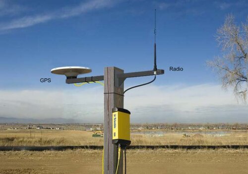
Base Station - courtesy of Trimble.com
A base station is a GPS receiver placed at an accurately known fixed location. It is used to derive correction information for nearby portable GPS receivers. Without these corrections, the location precision and accuracy of the GPS receivers would not be as exact as it is with the corrections. Specifically, the correction data allows any effect that was obtained by the mobile stations to be corrected out of the position data. One disadvantage of using a base station is that it needs to be manually set up which can be time-consuming. Another drawback of base stations is that they are limited to radio broadcast orbits which are shorter ranged than cellular-based VRS networks.
What are Virtual Reference Stations?

VRS - courtesy of MaineTechnical.com
Virtual Reference Stations are highly accurate and connect through cell coverage. So, unless you’re in a complete dead zone you can quickly and easily connect to the VRS system, such as Trimble’s VRS Now. This VRS method is a highly accurate and effectively managed solution. The main purpose of a VRS is to reduce the baseline distance between the rover and the reference station to efficiently remove spatially correlated errors. The process for doing this begins with the data from the reference stations being transmitted to the processing and control center at a one-second interval. The RTK user sends his/her approximate position. The processing center then determines which triangle that the user is stationed at, computes the imaginary VRS, and transmits the data to the user. The interpolated data obtains the correction data for the rovers which reduces the systematic influences of the RTK measurement.
VRS’ GPS accuracy is between one and two centimeters. To reach this level of accuracy it requires the use of precise dual-frequency carrier-phase observations which are processed using a differential GNSS algorithm such as RTK or post-processing (PP). GNSS networks make it possible to use multiple reference stations which results in more exact data modeling of distance-dependent systematic errors. The GNSS network can decrease the dependence of the error budget on the distance of the nearest antenna.
The Answer Could Be Both…
What does this mean to you? If you pay for a VRS subscription service and have the means of connecting your machine or rover with the VRS network (modem with sim card) then you can take advantage of the possibilities of using a VRS network. Using VRS means that you don’t need a base station set up on every job, allowing for a fast-paced work environment where you can bounce from job to job without taking a base station with you. Base stations are also very expensive which can limit the number of jobs you can work on at one time. Say you have a fleet of 5 GPS-equipped machines but only two base stations, without VRS, you could only work on two jobs at a time. With VRS, you are limited to the number of VRS subscriptions you have. This means that you would need to have 5 subscriptions if you wanted to have all machines run off VRS at the same time. A good compromise is to have one or two base stations for your large jobs and use VRS on your small jobs. This would allow you to have only two or three VRS subscriptions shared between your fleet and still have the flexibility that VRS allows.
ECI can Help!
Precision and accuracy are what our company was founded on. Whether it's CAD services, Cut and Fill Analysis, 3D Models, Mass Data, or to discuss your earthmoving projects in general, we are one easy phone call away.