
ECI Blog
Downloads


Tags
- 3D Digital Models 10
- 3d scanners 1
- AI in Construction 2
- AMG 1
- Artificial Intelligence 2
- As-Built 1
- Autocad 2
- Base and Rover 1
- Better meetings 1
- Big Data 3
- Big Data in Construction 3
- CAD 5
- CAD files 4
- Cad Services 1
- Changes in Construction 2
- Civil GPS systems 7
- Communication 2
- Conexpo 1
- Construction Data and Safety 5
- Construction Project Bidding 6
- Construction Takeoffs 7
- Construction control site networks 3
- Construction planning 2
- Construction projects 6
- Control Points 3
- Curbs 1
- DEM 1
- DSM 1
- DTM 4
- Dig safe 2
- Digital takeoffs 6
- Drone data 3
- Drones 2
- Earthwork drones 1
- Electronic Distance Measuring 1
- Ellipsoids 1
- Excavation Safety 2
- Excavation bidding process 3
- Excavation hybrid fleet 1
- GPS Machine Calibration 3
- GPS equipment software 5
- GPS/GNSS 8
- Geoids 2
- Heavy Equipment GPS 8
- Lidar 2
- Milling and Paving 1
- Milling and Paving Technologies 3
- Orthophotos 2
- Point Cloud 1
- RTK 3

ROVER GPS: SUPERCHARGE YOUR EQUIPMENT WITH PRECISION DATA
Rovers have many different uses in the construction industry and elsewhere because they're small, can be attached to almost anything, and provide very accurate information about your project. Depending on which device you're connecting your rover to, the level of accuracy will vary.

THE VALUE OF AS-BUILTS FOR WATER LINES
The main purpose of an as-built drawing is to record any changes made during the building process that deviate from the original plan. As-builts are useful for many reasons, one being the value they bring to water lines which in our opinion are some of the most troublesome proposed utilities on a job site.

ADVANCES IN EARTHMOVING CONSTRUCTION: GPS JOINS THE 90’S SCENE
We all know that computers are significant in today’s world, and its impact on the construction industry is no exception. Whether it is the computer systems that are being used to design projects or the machinery used to build them, computers are critical to the project’s success. For example, the days of designing sites using hand-drawings or blueprints are long gone, and that includes redlines of the blueprints which were replaced by As-Builts. Systems such as computer-aided designs (CAD) have taken the place of blueprints and become more sophisticated from year to year.

SINGLE-POINT CALIBRATION: WHEN IS ONE POINT ENOUGH?
It’s essential to get accurate site calibrations when it comes to earthmoving projects. A single-point calibration is the simplest type of calibration performed. Site calibrations are necessary because they enable multiple GNSS-based rover systems to work in your local site's coordinate system. How do you know when a single-point calibration is sufficient or not? We'll share some information and advice to help you figure it out!

THE SIGNIFICANT ROLE THAT TINS PLAY IN CIVIL ENGINEERING
Geometry is the basis for civil engineering. You may have heard the term TIN when speaking with a civil engineer about a surface model for your project. So, what is this TIN thing you hear them talking about? Basically, it’s a bunch of triangles all joined continuously together at their points (vertices). TINs provide a visual of a topographical surface and are the building blocks for creating 3D surface models of civil works.
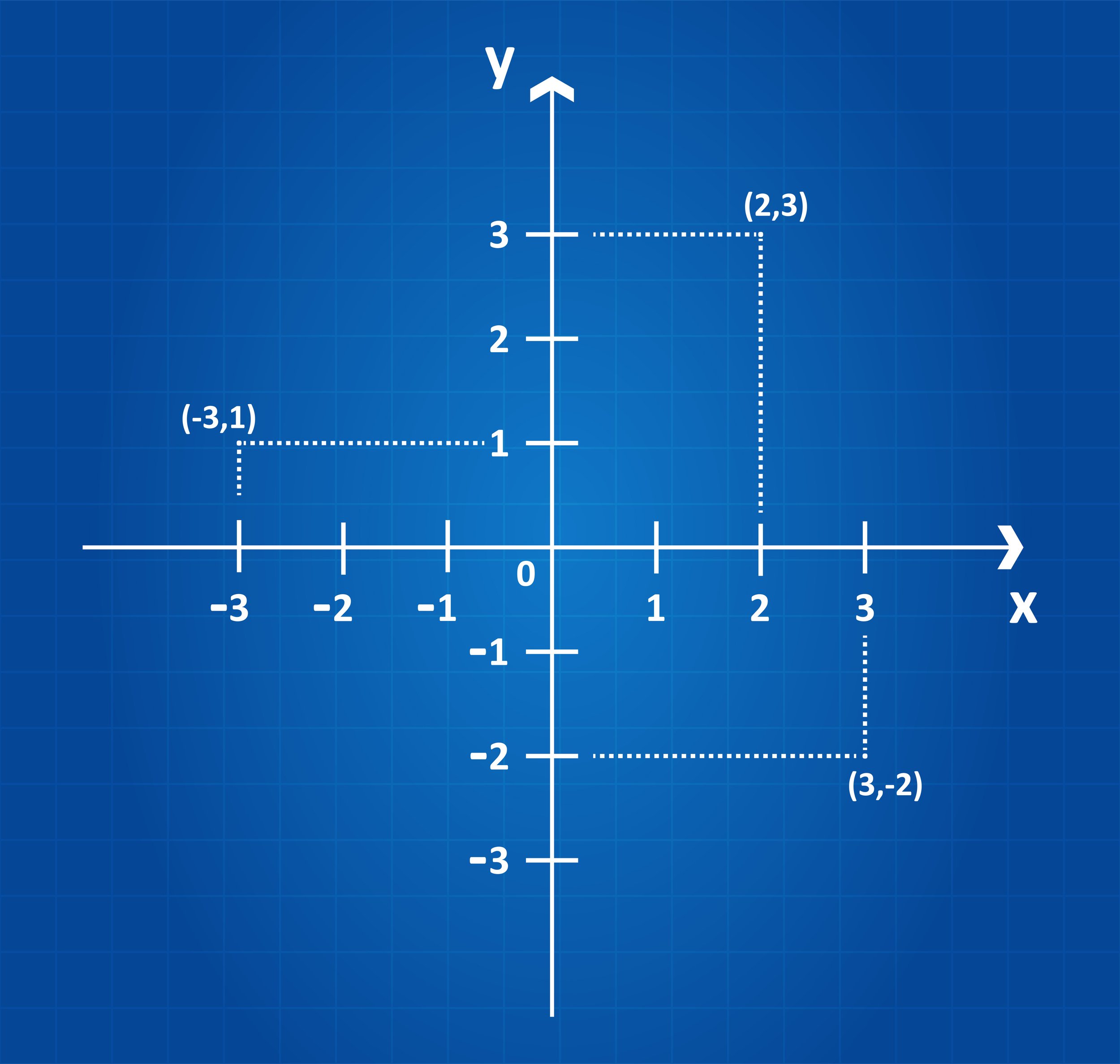
COORDINATE SYSTEMS 101: WHY THEY CAN MAKE OR BREAK A PROJECT
A construction project’s success factor begins with accurate survey data and the coordinate system it is based on. The coordinate system is the source for obtaining the precise survey data. Coordinates are necessary when laying projects out, whether it’s a highway, bridge, site work, utilities, or another type of construction project.

GRADING SURFACES: WHAT ARE THEY? HOW DO THEY IMPROVE CONSTRUCTION PROJECTS?
Are you wondering how a surface model will work with your heavy equipment? Although it can seem complex, it is simpler than you may think. Some machines already come equipped with the technology and others can be retrofitted with aftermarket technology systems. Either way, the most important thing to understand is that they run off GPS.
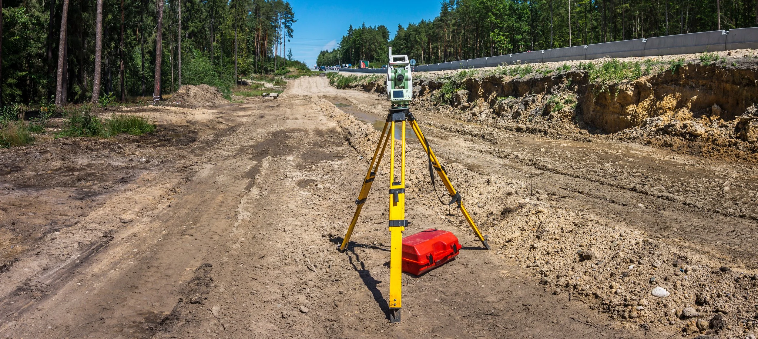
TOTAL STATIONS: HOW THEY IMPROVE DATA & ACCURACY ON JOB SITES
Have you ever been on a job site where the engineer only used a transit or theodolite to check grades? It takes them so long to set up, find their benchmark, measure the point, and calculate an elevation that you might as well send the crew home because it takes so long. Fortunately for you, most engineers these days use total stations or GPS rovers to check grades.