Learning Center
Downloads


Tags
- 3D Digital Models 7
- 3d scanners 1
- AI in Construction 1
- AMG 1
- Artificial Intelligence 1
- As-Built 1
- Autocad 2
- Base and Rover 1
- Better meetings 1
- Big Data 2
- Big Data in Construction 3
- CAD 5
- CAD files 4
- Cad Services 1
- Changes in Construction 2
- Civil GPS systems 5
- Communication 2
- Conexpo 1
- Construction Data and Safety 3
- Construction Project Bidding 6
- Construction Takeoffs 6
- Construction control site networks 2
- Construction planning 2
- Construction projects 6
- Control Points 3
- Curbs 1
- DEM 1
- DSM 1
- DTM 4
- Dig safe 1
- Digital takeoffs 6
- Drone data 2
- Drones 2
- Earthwork drones 1
- Electronic Distance Measuring 1
- Ellipsoids 1
- Excavation Safety 1
- Excavation bidding process 3
- Excavation hybrid fleet 1
- GPS Machine Calibration 3
- GPS equipment software 4
- GPS/GNSS 8
- Geoids 2
- Heavy Equipment GPS 6
- Lidar 2
- Milling and Paving 1
- Milling and Paving Technologies 1
- Orthophotos 2
- Point Cloud 1
- RTK 3
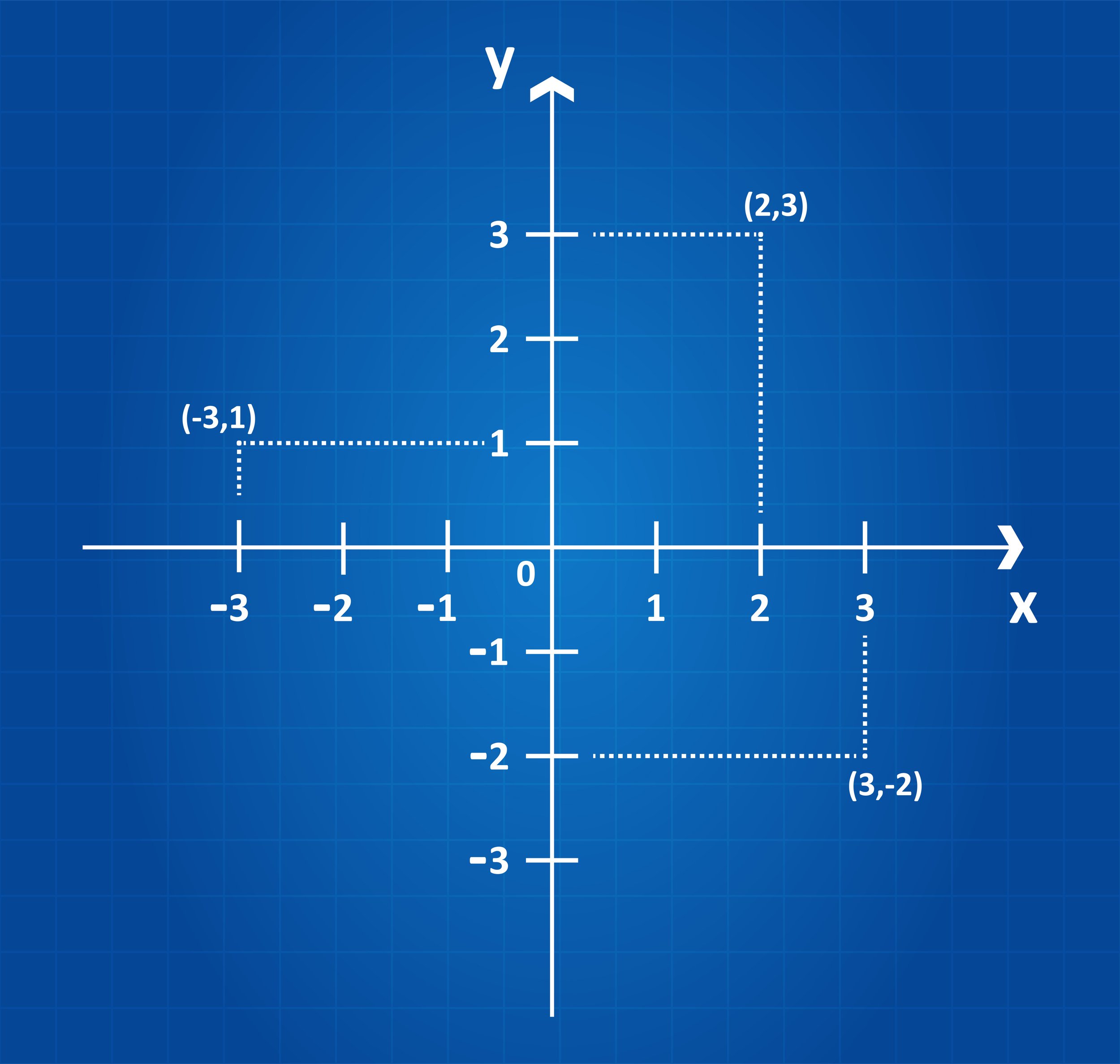
COORDINATE SYSTEMS 101: WHY THEY CAN MAKE OR BREAK A PROJECT
A construction project’s success factor begins with accurate survey data and the coordinate system it is based on. The coordinate system is the source for obtaining the precise survey data. Coordinates are necessary when laying projects out, whether it’s a highway, bridge, site work, utilities, or another type of construction project.

ARTIFICIAL INTELLIGENCE’S USEFULNESS IN CONSTRUCTION
CONEXPO CON/AGG 2023 is coming up quick and if you’re headed to Las Vegas you’re sure to see many cool Artificial Intelligence options that can be useful in construction project management. From the bidding stage through completion, there are many reasons why you might want to consider adding AI into your workflows.

ECI TECHNOLOGIES ENTERS INTO STRATEGIC PARTNERSHIP WITH JESCO EQUIPMENT
ECI Technologies today announced a strategic partnership with JESCO Equipment, headquartered in South Plainfield, NJ. This partnership will provide technology packages and increased service levels for JESCO Equipment’s customers.

GRADING SURFACES: WHAT ARE THEY? HOW DO THEY IMPROVE CONSTRUCTION PROJECTS?
Are you wondering how a surface model will work with your heavy equipment? Although it can seem complex, it is simpler than you may think. Some machines already come equipped with the technology and others can be retrofitted with aftermarket technology systems. Either way, the most important thing to understand is that they run off GPS.

SAVE TIME AND RESOURCES WITH MASS DATA CAPTURE
Drones have proven to be an excellent tool for collecting mass data. Despite the obvious upfront cost for purchasing the drone, it is an inexpensive way to collect the data compared to conventional means. This method has many advantages, including speed, reliability, accuracy, cost-effectiveness, and more.

DIGITAL TAKEOFFS: FACTORS THAT WILL IMPACT QUANTITIES
Without a thorough takeoff (cut and fill) process to accurately quantify the materials needed for your project, your estimates can be way off. Whether you're using a manual process or a digital process, errors in takeoffs result in inaccurate bids and additional expenses.
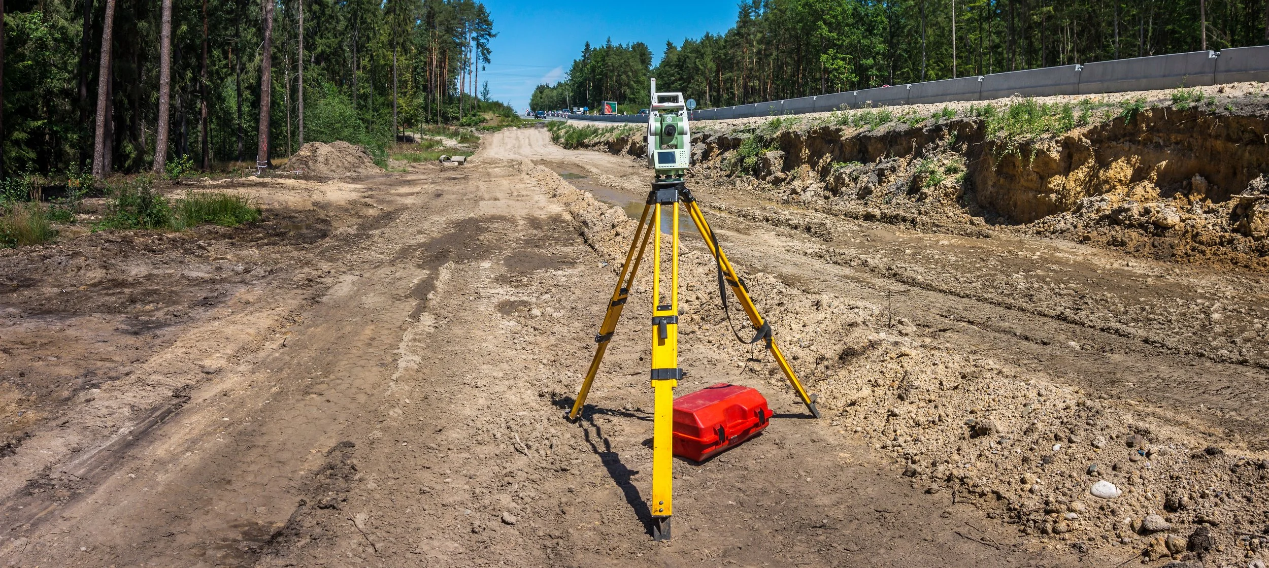
TOTAL STATIONS: HOW THEY IMPROVE DATA & ACCURACY ON JOB SITES
Have you ever been on a job site where the engineer only used a transit or theodolite to check grades? It takes them so long to set up, find their benchmark, measure the point, and calculate an elevation that you might as well send the crew home because it takes so long. Fortunately for you, most engineers these days use total stations or GPS rovers to check grades.

GOOD CONTROL SURVEYS LEAD TO BETTER CONTROL POINTS
The evolution of surveying over the years is very impressive. What used to take months to do years ago has been reduced to days or hours in modern-day surveying. There are many different methods used by surveyors. This blog will cover some of those methods.

SPOT ELEVATIONS: WHEN TO USE THEM INSTEAD OF CONTOUR LINES
Are you having trouble deciding when to use spot elevations versus contour lines to determine your breaklines? Well, don't worry because you're not alone. We are often confronted with that question and are here to help you figure it out.

STOCKPILE SURVEY: DRONES MAKE IT SAFER AND MORE EFFICIENT
Drones can survey a site very quickly, efficiently, and safely. The drone is taking aerial photos through photogrammetry to stitch together the images on the ground while also using GPS and ground control to tie those images down. After the flight, the data is processed through a software program (i.e.: Propeller or Pix4D) which renders everything in 3D.

IN-HOUSE ENGINEERS: HOW WE CAN MAKE THEM EVEN BETTER
We are often asked how we can provide value to a road, utility, or site contractor who already has an in-house GPS model builder. The answer is simple, we work collaboratively with them to add the modeling expertise of our VCEs, we take up the slack to get large projects ready for construction, and we bring more modeling tools to the table.

HOW TO MEASURE THE ROI OF CIM
By bringing together virtual models, data analytics, systems, people, and improved workflows through CIM you will gain efficiencies in every phase. Stakeholders will be able to easily access and rely on accurate and timely information which will enable them to do their jobs better. Your projects will not run behind schedule as often and your overall costs will decrease.

3 EASY STEPS TO WORKING WITH A GPS MACHINE CONTROL DATA PROVIDER
So, you’ve invested in some GPS machine control technology. You’ve weighed the option of training or hiring an in-house person versus hiring an external service provider to handle the data prep. Based on your research, you’ve decided to partner with an external company that specializes in data prep and want to know what the next steps are.

PROJECT TURNAROUND: PROBLEMS THAT AFFECT SPEED AND HOW TO AVOID THEM
A question we are frequently asked by our clients and prospective clients is “What is the turnaround time for this project?”. Generally speaking, we typically run on average with a two-week turnaround time but situations sometimes impact that timeline which means it could take longer. Let’s go over some problems that impact the speed of model building.

UNDERSTANDING THE COST OF A 3D ROAD MODEL: FACTORS THAT IMPACT PRICE
The increased use of GPS systems for construction projects has led to contractors often asking themselves or service providers like us, “What does a 3d road model cost?”. Typically, you’ll hear the standard reply of “it depends” which it does. However, we’re going to explain why it depends and what each type might generally cost.

CONSIDERING A CAREER IN CONSTRUCTION? HERE ARE MANY REASONS WHY YOU SHOULD
There are tons of specialties that one can build off of within construction. Not everyone has to be a carpenter or a heavy equipment operator. However, if you do start in one of those jobs, your chances to further build out your skills are plentiful.

CIVIL ENGINEERING AND LANDSCAPE ARCHITECTURE: TWO EXCELLENT PROFESSIONS IN CONSTRUCTION
Continuing our support for Careers in Construction month by giving you information about two exciting professions: civil engineering, and landscape architecture. Some might think they’re very similar, however, they differ quite a bit.

THE ROLE OF VCEs AND THE TOP 3 WAYS THEY ADD VALUE
In tribute to October’s Careers in Construction month, we’re sharing what it’s like to pursue a career as a Virtual Construction Engineer (VCE). It’s not necessarily a widely known term, so we’re glad to share our knowledge as well as some insights from our very own VCEs.
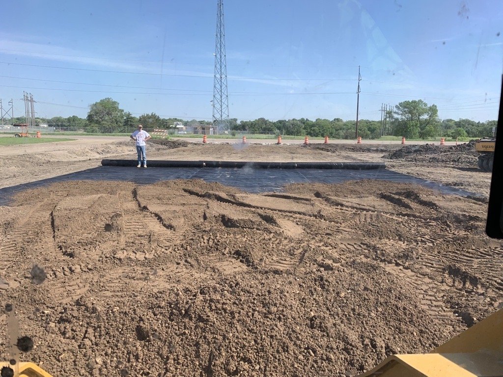
THE ADVANTAGES OF GEOTEXTILES FOR EROSION CONTROL AND MORE ON JOB SITES
When was the last time you were on a job site where you didn't see large rolls of fabric lying around somewhere? You'd probably have to go way back in your memory bank to find one. These penetrable fabrics, called geotextiles, are an essential part of most construction projects today. When used in construction projects, they have numerous advantages.

ROAD GRADERS WITH GPS ARE A MUST HAVE FOR YOUR HEAVY EQUIPMENT FLEET
Dozers are arguably the coolest piece of heavy equipment out there; however, we can make a strong case for the road grader. Long gone are the days of graders being pulled by horses and tractors! The power and versatility of a modern-day road grader are two of the top reasons we consider it to compete with the dozer for being badass.
Videos

Consideration When Buying a Drone

What Happens When You Start Working with ECI

How ECI Gives Your In-house GPS a Boost

How Much Does A Road Model Cost?