
Learning Center
Downloads


Tags
- 3D Digital Models 9
- 3d scanners 1
- AI in Construction 1
- AMG 1
- Artificial Intelligence 1
- As-Built 1
- Autocad 2
- Base and Rover 1
- Better meetings 1
- Big Data 2
- Big Data in Construction 3
- CAD 5
- CAD files 4
- Cad Services 1
- Changes in Construction 2
- Civil GPS systems 7
- Communication 2
- Conexpo 1
- Construction Data and Safety 5
- Construction Project Bidding 6
- Construction Takeoffs 6
- Construction control site networks 3
- Construction planning 2
- Construction projects 6
- Control Points 3
- Curbs 1
- DEM 1
- DSM 1
- DTM 4
- Dig safe 2
- Digital takeoffs 6
- Drone data 3
- Drones 2
- Earthwork drones 1
- Electronic Distance Measuring 1
- Ellipsoids 1
- Excavation Safety 2
- Excavation bidding process 3
- Excavation hybrid fleet 1
- GPS Machine Calibration 3
- GPS equipment software 5
- GPS/GNSS 8
- Geoids 2
- Heavy Equipment GPS 8
- Lidar 2
- Milling and Paving 1
- Milling and Paving Technologies 3
- Orthophotos 2
- Point Cloud 1
- RTK 3

MILLING & PAVING: HOW DATA MAKES ROADWORK REVOLUTIONARY
Milling machine manufacturers have developed technology that has enabled significant process improvements since the invention of the Roto-Mill in the mid-1970s. The amount of asphalt that a milling machine could cut during, let's say, two hours back in the 1980s compared to today is night and day. If you're still handling your paving jobs without the advanced machine technology, it's time to take your process to the next level, which will save you time and money!

2 PROVEN METHODS TO IMPROVE CONSTRUCTION PROJECT MEETINGS
Construction project meetings include stakeholders from many different areas. Meeting participants can range from those with a deep knowledge base like the developer or contractor to individuals from the finance area who are looking at it through a different lens. All perspectives are valuable; however, it can be challenging to effectively facilitate these meetings and ensure that each individual walks away with the information they need to contribute to the project’s success.

GEOID MODELS: WHAT ARE THEY? WHAT IS THEIR PURPOSE IN CIVIL ENGINEERING?
In our industry, precision is one of the most fundamental factors to successful project execution. Precise measurements lead to precise calculations, precise calculations lead to precise specifications, and ultimately that all leads to better project outcomes. Being able to calculate accurate local elevation for job sites is essential. However, our planet is not the perfectly round, smooth shape that some think it is. Earth is very bumpy and irregular. This irregular shape is called the geoid.

GPS MACHINE CONTROL: WHAT’S THE DIFFERENCE BETWEEN ALL THE FILE TYPES?
Depending on which brand of GPS equipment you’re using the file types and therefore file extensions will differ. The reason for this is that the brands each have their proprietary systems with their own file types as opposed to universal ones. For example, have you received files ending in .ttm, .dxf, .csv, .tn3, .ln3, or others and wondered what’s the difference between them?

TRENCHING IN CONSTRUCTION: HOW TO BE SAFE EVEN WITH ATYPICAL SURFACES
Trenching and excavating – these top the list as the most hazardous operations in our industry. They cannot be avoided, however, as they play a significant role in civil engineering. Being careless or making mistakes could lead to fatalities among your work crew. So, what can you do to keep your job site and workers in the safest possible conditions?

THE SIGNIFICANT ROLE THAT TINS PLAY IN CIVIL ENGINEERING
Geometry is the basis for civil engineering. You may have heard the term TIN when speaking with a civil engineer about a surface model for your project. So, what is this TIN thing you hear them talking about? Basically, it’s a bunch of triangles all joined continuously together at their points (vertices). TINs provide a visual of a topographical surface and are the building blocks for creating 3D surface models of civil works.

3 PRIMARY ADVANTAGES OF USING DRONES DURING PRECONSTRUCTION
Some of you may already be flying a drone over your worksite during the preconstruction phase and have recognized how beneficial it is to have incorporated this into your standard process. Some of you have not. We’ve identified a few key reasons why everyone should.

HOW TO BEST ACCOUNT FOR CHANGES IN YOUR BIDDING PROCESS
Over the years, we have come across different reasons for suboptimal bids. The most common reasons are all related to, you can probably guess it, changes! Many changes occur throughout a project's lifecycle. Sometimes they start as early as the bid phase. Changes to the project's scope that happen pre-bid are usually referred to as addendums. A few of these pre-bid changes come to mind.
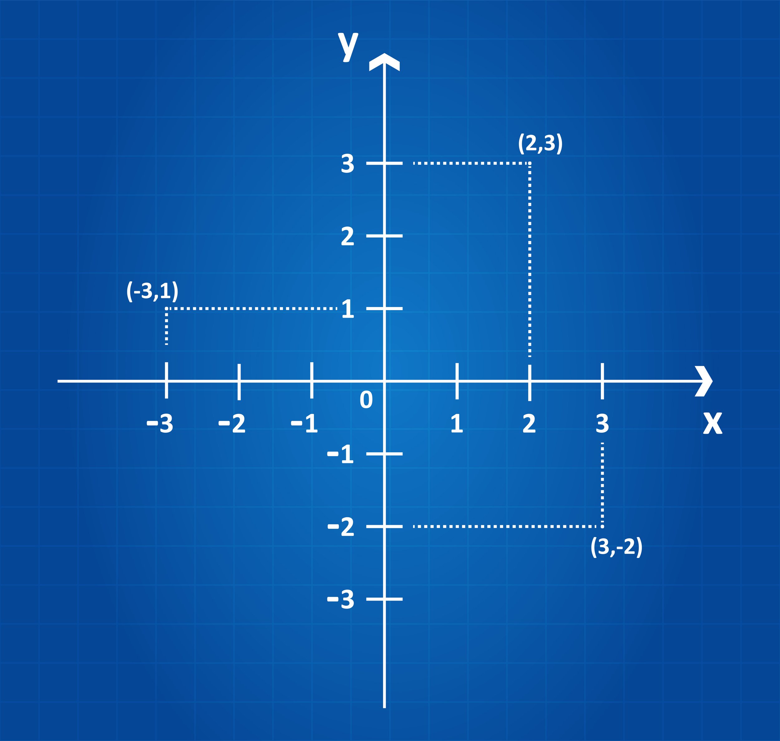
COORDINATE SYSTEMS 101: WHY THEY CAN MAKE OR BREAK A PROJECT
A construction project’s success factor begins with accurate survey data and the coordinate system it is based on. The coordinate system is the source for obtaining the precise survey data. Coordinates are necessary when laying projects out, whether it’s a highway, bridge, site work, utilities, or another type of construction project.

ARTIFICIAL INTELLIGENCE’S USEFULNESS IN CONSTRUCTION
CONEXPO CON/AGG 2023 is coming up quick and if you’re headed to Las Vegas you’re sure to see many cool Artificial Intelligence options that can be useful in construction project management. From the bidding stage through completion, there are many reasons why you might want to consider adding AI into your workflows.

ECI TECHNOLOGIES ENTERS INTO STRATEGIC PARTNERSHIP WITH JESCO EQUIPMENT
ECI Technologies today announced a strategic partnership with JESCO Equipment, headquartered in South Plainfield, NJ. This partnership will provide technology packages and increased service levels for JESCO Equipment’s customers.

GRADING SURFACES: WHAT ARE THEY? HOW DO THEY IMPROVE CONSTRUCTION PROJECTS?
Are you wondering how a surface model will work with your heavy equipment? Although it can seem complex, it is simpler than you may think. Some machines already come equipped with the technology and others can be retrofitted with aftermarket technology systems. Either way, the most important thing to understand is that they run off GPS.

SAVE TIME AND RESOURCES WITH MASS DATA CAPTURE
Drones have proven to be an excellent tool for collecting mass data. Despite the obvious upfront cost for purchasing the drone, it is an inexpensive way to collect the data compared to conventional means. This method has many advantages, including speed, reliability, accuracy, cost-effectiveness, and more.

DIGITAL TAKEOFFS: FACTORS THAT WILL IMPACT QUANTITIES
Without a thorough takeoff (cut and fill) process to accurately quantify the materials needed for your project, your estimates can be way off. Whether you're using a manual process or a digital process, errors in takeoffs result in inaccurate bids and additional expenses.
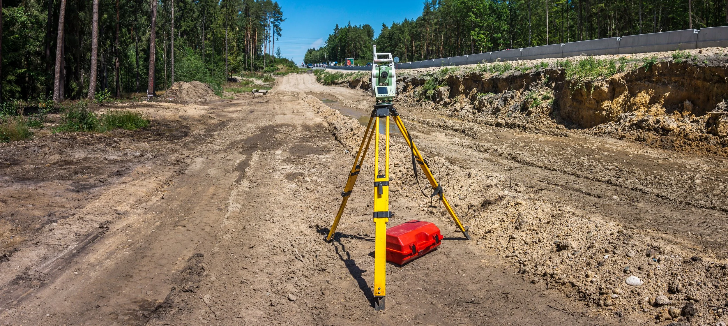
TOTAL STATIONS: HOW THEY IMPROVE DATA & ACCURACY ON JOB SITES
Have you ever been on a job site where the engineer only used a transit or theodolite to check grades? It takes them so long to set up, find their benchmark, measure the point, and calculate an elevation that you might as well send the crew home because it takes so long. Fortunately for you, most engineers these days use total stations or GPS rovers to check grades.

GOOD CONTROL SURVEYS LEAD TO BETTER CONTROL POINTS
The evolution of surveying over the years is very impressive. What used to take months to do years ago has been reduced to days or hours in modern-day surveying. There are many different methods used by surveyors. This blog will cover some of those methods.

SPOT ELEVATIONS: WHEN TO USE THEM INSTEAD OF CONTOUR LINES
Are you having trouble deciding when to use spot elevations versus contour lines to determine your breaklines? Well, don't worry because you're not alone. We are often confronted with that question and are here to help you figure it out.

STOCKPILE SURVEY: DRONES MAKE IT SAFER AND MORE EFFICIENT
Drones can survey a site very quickly, efficiently, and safely. The drone is taking aerial photos through photogrammetry to stitch together the images on the ground while also using GPS and ground control to tie those images down. After the flight, the data is processed through a software program (i.e.: Propeller or Pix4D) which renders everything in 3D.

IN-HOUSE ENGINEERS: HOW WE CAN MAKE THEM EVEN BETTER
We are often asked how we can provide value to a road, utility, or site contractor who already has an in-house GPS model builder. The answer is simple, we work collaboratively with them to add the modeling expertise of our VCEs, we take up the slack to get large projects ready for construction, and we bring more modeling tools to the table.

HOW TO MEASURE THE ROI OF CIM
By bringing together virtual models, data analytics, systems, people, and improved workflows through CIM you will gain efficiencies in every phase. Stakeholders will be able to easily access and rely on accurate and timely information which will enable them to do their jobs better. Your projects will not run behind schedule as often and your overall costs will decrease.
Videos

Consideration When Buying a Drone

What Happens When You Start Working with ECI

How ECI Gives Your In-house GPS a Boost

How Much Does A Road Model Cost?