Learning Center
Downloads


Tags
- 3D Digital Models 7
- 3d scanners 1
- AI in Construction 1
- AMG 1
- Artificial Intelligence 1
- As-Built 1
- Autocad 2
- Base and Rover 1
- Better meetings 1
- Big Data 2
- Big Data in Construction 3
- CAD 5
- CAD files 4
- Cad Services 1
- Changes in Construction 2
- Civil GPS systems 5
- Communication 2
- Conexpo 1
- Construction Data and Safety 3
- Construction Project Bidding 6
- Construction Takeoffs 6
- Construction control site networks 2
- Construction planning 1
- Construction projects 6
- Control Points 3
- Curbs 1
- DEM 1
- DSM 1
- DTM 4
- Dig safe 1
- Digital takeoffs 6
- Drone data 2
- Drones 2
- Earthwork drones 1
- Electronic Distance Measuring 1
- Ellipsoids 1
- Excavation Safety 1
- Excavation bidding process 3
- Excavation hybrid fleet 1
- GPS Machine Calibration 3
- GPS equipment software 4
- GPS/GNSS 8
- Geoids 2
- Heavy Equipment GPS 6
- Lidar 2
- Milling and Paving 1
- Milling and Paving Technologies 1
- Orthophotos 2
- Point Cloud 1
- RTK 3
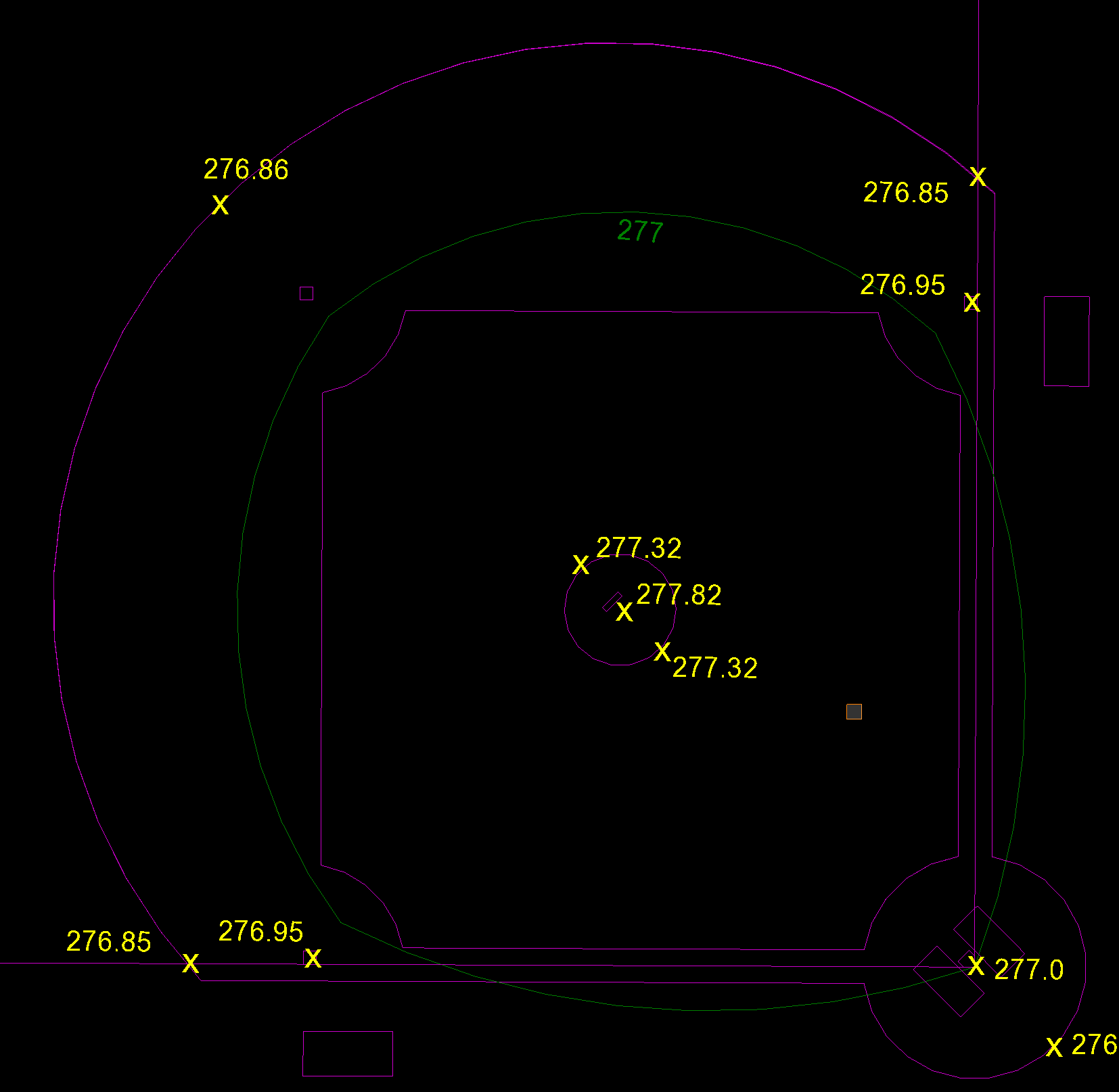
BREAKLINES: WHAT ARE THEY AND WHY ARE THEY IMPORTANT IN SURFACE MODELS
Breaklines are essential for creating a precise 3D surface model. Breaklines connect data representing specific features on a surface, such as the centerline of a road, a ridgeline, or a ditch's flowline. Whether to use spot elevations or contour lines to determine your breaklines is not always clear. Here, we help shed some light on the differences between contour lines and spot elevations and provide guidance on when to use which one.
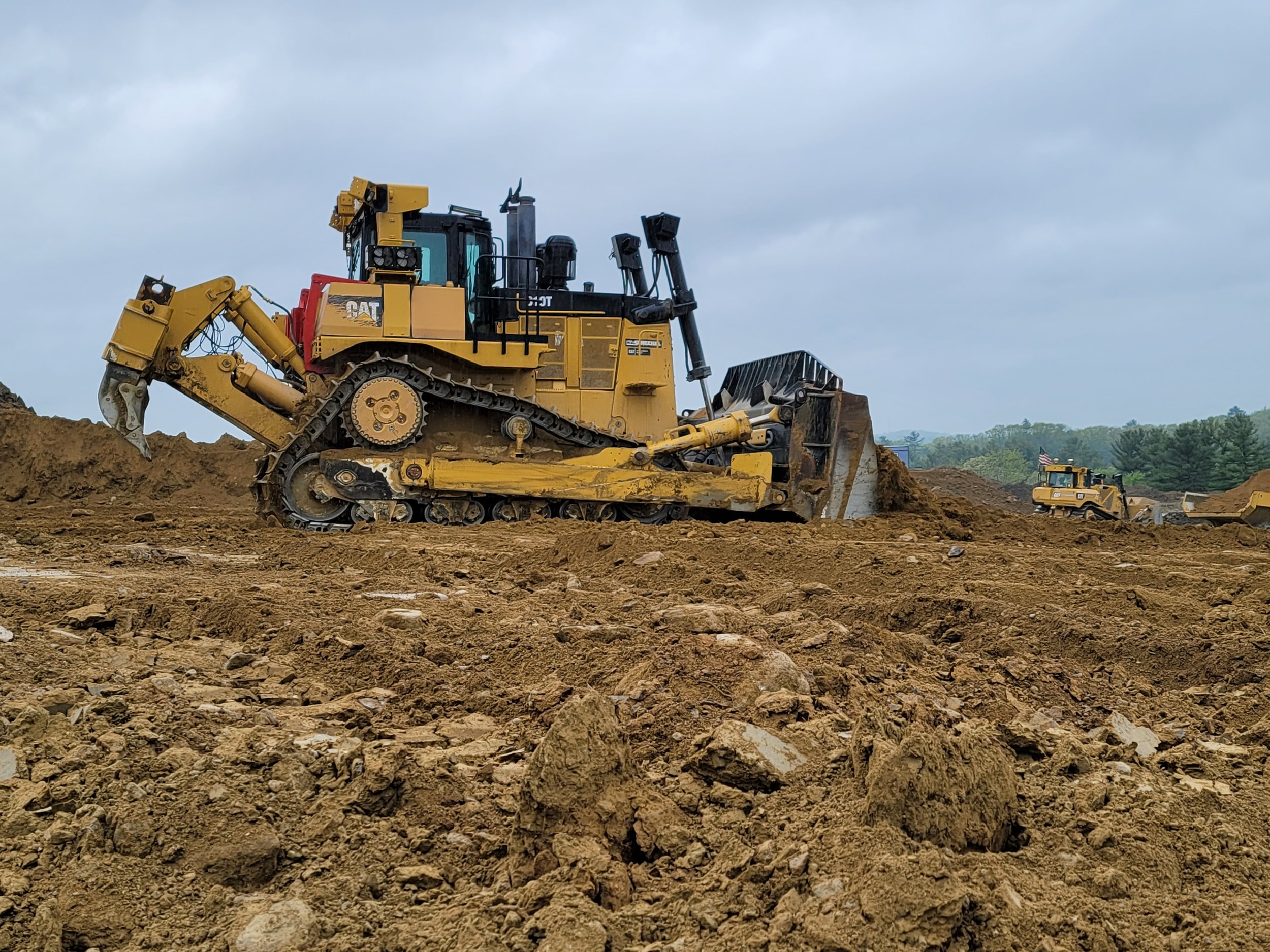
BULLDOZERS: ALL YOU SHOULD KNOW ABOUT THEM AND HOW GPS IMPROVED THEM
For GPS to work successfully and efficiently in earthwork, there must be accurate 3D models loaded into the dozer or other heavy machinery. GPS has become more of the industry standard, and we expect there will not be many site contractors running projects without GPS on their equipment. The benefits are far too great not to make the switch.

HOW BEST TO DEPLOY BASE STATIONS AND VIRTUAL REFERENCE STATIONS
Land surveyors have been using GPS receivers at a known position, called base stations, for a long time, and that method continues to be effective and used a lot. However, there's also the option of using a virtual reference station (VRS) instead of a base station. A VRS is a technique for network RTK for GPS systems. How do you choose between a base station and a VRS? Well, there are pluses and minuses with each system, so it depends.

THE IMPORTANCE OF COMPLYING WITH ADA IN CONSTRUCTION AND HOW ECI HELPS
The American Disabilities Act of 1990 (ADA) is one of the most important considerations that must be factored into all construction projects, whether new construction or renovation. Numerous ADA guidelines must be followed when constructing, for example, sidewalks, ramps, parking spaces, or buildings. Not following them will result in hefty fines, which can reach as high as $150,000 depending on the number of violations.

CLIENT SPOTLIGHT! S&K CONTRACTING OF VIRGINIA AND ECI's PARTNERSHIP ON A HUGE SUBDIVISION
We genuinely value our client partnerships and want to share some of our experiences with you whenever possible through a Client Spotlight. In particular, we are working with a contractor out of Western Virginia, S&K Contracting Inc., that approached us recently about a subdivision project. Their enthusiasm for their work is contagious, and for that reason, we have decided to shine a light on them.

GPS ROVER AND BASE: FOR ALL-IMPORTANT ACCURACY, IT'S ALL ABOUT LOCATION
Rovers and base stations have been around and used in our industry for a long time. When paired with the GPS Real-Time Kinematic (RTK) operation, it gives you impeccable accuracy down to the centimeter. Choosing the best location for set up on the job site is the most crucial first step towards obtaining the best data possible.

VRS VS BASE STATION: WHICH IS THE RIGHT FIT FOR YOUR SITE?
The 90s were a great decade for many reasons including a lot of technological inventions like Adobe Photoshop, Linux, text messages, Nintendo, Google, and more. Among the myriad of discoveries was also the Virtual Reference Station which came to be in 1997. A Virtual Reference Station (VRS) is a technique for network real-time kinematic (RTK) for GPS systems. Before VRS, surveyors used the base station method.

SOIL SWELL: ACCOUNTING FOR SHRINKING AND BULKAGE IN TAKEOFFS
Moving dirt, it's what we do and what we love to do! It is super important to have a firm understanding of how soil shrinks and swells. When soil is moved from one location to another, its volume changes, and this is known as either shrink or swell.

EVERYTHING YOU NEED TO KNOW ABOUT CONSTRUCTION SITE CONTROL POINTS
Have you ever stopped and given control points a second thought? Probably not. However, we felt obligated to dedicate a blog to the importance of control points because without them, quite frankly, there would be nothing more to the job site. So, let's dig into the 4 Ws of Control Points and give them the attention they deserve!
Videos

Consideration When Buying a Drone

What Happens When You Start Working with ECI

How ECI Gives Your In-house GPS a Boost

How Much Does A Road Model Cost?